Free geotechnical software for Windows
Geotechnical software, built by geotechnical engineers.
GeoEQ makes the programs that turn site investigation data into drawings and decisions — borehole logging, soil classification, laboratory testing and foundation design. Start with SPT Logs: free, offline, unlimited.
Free for Windows · No account · Works offline
- Programs in the suite
- 4 Programs in the suite
- Applications covered
- 24 Applications covered
- Boreholes per project
- No limit Boreholes per project
- Offline · your data stays yours
- 100% Offline · your data stays yours
Applications
From the first blow count to the final foundation.
Every discipline of a site investigation, handled by software that shares one data model — so nothing is re-typed between the field, the laboratory and the design desk.
Site investigation
Field · Logging
- SPT borehole logs
- Strata & soil profiling
- Sampling records (D / UD)
- Groundwater levels
- Rock coring: TCR / SCR / RQD
- Fence diagrams & sections
Laboratory
Samples · Testing
- Grain size distribution
- Atterberg limits (LL / PL / PI)
- USCS & AASHTO classification
- Moisture content & density
- Unconfined compression
- Consolidation & shear
Foundation design
Structure · Design
- Bearing capacity (shallow)
- Settlement analysis
- Pile capacity — driven & bored
- Pile group & cap design
- Lateral earth pressure
- N-value correlations (N60, N1(60))
Seismic & ground response
Site effects · Research
- Site classification (Vs30)
- Liquefaction triggering
- 1-D site response
- Design response spectra
- Seismic settlement
- Ground motion visualisation
The software
Four programs, one investigation.
Start with the free borehole logger. Each program that follows reads the data the last one produced.
GeoEQ SPT Logs
Borehole logging · Windows
Turn field sheets into publication-ready borehole logs. Blow counts, strata, samples and groundwater — drawn to your company letterhead and exported as a single PDF for the whole site.
- SPT & sampling
- USCS symbols
- Excel import
- Multi-project
- PDF export
GeoEQ GeoLab
Soil laboratory testing
The laboratory half of the investigation: grain size curves, Atterberg limits and classification computed and charted as the technician types, with results flowing straight back onto the borehole log.
- Sieve & hydrometer
- Atterberg
- USCS / AASHTO
- Test certificates
GeoEQ CAP & Pile
Foundation design
Bearing capacity, settlement and pile design driven directly by the logged profile — with every intermediate value visible, so the calculation can be checked by the engineer who signs it.
- Shallow foundations
- Driven & bored piles
- Settlement
- Design reports
GeoEQ Seismo
Seismic site response
Site classification, liquefaction screening and one-dimensional ground response computed on the same soil profile — because the seismic check should not start with a fresh spreadsheet.
- Vs30 & site class
- Liquefaction
- Response spectra
- Wave propagation
Shipping today
The borehole log draws itself while you type.
No drawing work, no template surgery. Enter the field data on the left and the finished sheet builds on the right — scaled, paginated and ready to sign.
- Live preview. Every keystroke redraws the sheet — ruler scale, soil symbols, N-value profile.
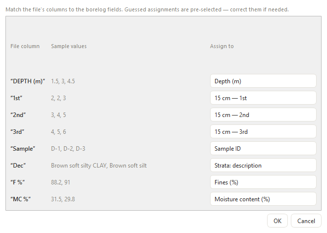
- Import what you already have. Excel or CSV with any column headings; a mapping dialog does the rest.
- One PDF for the site. Every borehole in a project exported in a single click, correctly paginated.
- Your letterhead. Company logo, accent colour and four header layouts — it looks like your office signed it.
Drawn to the conventions you already sign to
- ASTM D1586 — SPT
- ASTM D2487 — USCS
- ASTM D2488
- BS 5930
- IS 2131
Our open source · Apache 2.0
Our geotechnical Python package is open source — and always will be.
geoeq is the engine
inside our software, published for everyone.
170+ validated functions across soil classification,
laboratory testing, site investigation, foundation design and soil dynamics —
because an engineer should be able to read the equation behind any number they
are asked to sign.
- Free forever
- Commercial use allowed
- No account
- Citable in research
- 170+
- validated functions
- Apache 2.0
- licence — commercial use allowed
- Python 3.9 – 3.13
- supported
- 3
- dependencies only
$ pip install geoeq
import geoeq as ge

# Bearing capacity of a shallow foundation
result = ge.bearing_capacity(
    c=25, gamma=18, Df=1.5, B=2,
    phi=30, method="meyerhof",
)
print(result["q_u"])   # ultimate bearing capacity, kPa
Flat API — every function at the top level. Depends on numpy · scipy · matplotlib.
Soil properties & classification
Index properties and group symbols computed the way the standards define them.
- USCS (ASTM D2487)
- AASHTO M145
- Atterberg limits
- USDA texture triangle
Laboratory testing
Reduce test data to the parameters a design actually consumes.
- Grain size
- Shear & triaxial
- Consolidation
- Compaction & permeability
Site investigation
Field measurements, corrections and correlations in one place.
- SPT & N-value corrections
- CPT
- Vane & pressuremeter
- DCP & pile load tests
Foundation & geotechnical design
The calculations behind a foundation report, with every step callable.
- Bearing capacity
- Settlement
- Earth pressure
- Piles & slope stability
Soil dynamics & earthquake engineering
Seismic screening on the same profile you logged in the field.
- Liquefaction triggering
- NCEER procedure
- Idriss–Boulanger
- Cyclic stress ratio
Stress, seepage & profiles
Layered profiles with the stress state resolved at any depth.
- Total & effective stress
- Pore pressure
- Seepage
- Layered profiles
Documentation at docs.geoeq.org · package home at geoeq.org · source at github.com/geoeq/geoeq
Every step of the way
Pick it up in an afternoon. Get help the same week.
Find the right program
Not sure which tool covers your scope? Tell us the job — borehole logging, laboratory, foundations — and we will point you at the right one, free version included.
Compare the softwareLearn it properly
A full user manual, worked examples from a real site investigation, and short guides on importing messy field spreadsheets without losing a row.
Read the manualTalk to an engineer
Support is answered by the people who wrote the software — not a ticket queue. Bugs get fixed in days, and requests land on a public roadmap.
Open a discussionRoadmap
Built in the open, in the order engineers ask for.
Every item below came from a practising engineer. Requests are public, and the 1.x line stays free.
- RELEASED v1.0 · shipped
Column mapping for messy spreadsheets
Import Excel or CSV with any headings — assign columns before a row is written.
- RELEASED v1.2 · shipped · requested from the Gulf region
Rock coring — TCR, SCR and RQD
Core-run table, one nested recovery bar coloured by RQD rock quality, and a log that continues past refusal into rock.
- IN PROGRESS Requested · United States
Imperial units
Depths in feet, qu in tsf/ksf, boring diameter in inches — with optional dual display.
- PLANNED v1.5
Custom soil colours and columns
Recolour any soil type, hide unused columns, add computed columns such as N60.
- PLANNED v1.5
Field-sheet extraction from photos
Photograph a handwritten log; review the recognised table before it enters the project.
Questions
Straight answers about the software.
Still unsure? Ask in the discussions — questions are answered by the engineers who build it.
Is GeoEQ geotechnical software really free?
Yes. GeoEQ SPT Logs version 1.x is free for commercial and academic use, with no account, no licence key and no expiry. Download the Windows installer or the portable version and use it on as many projects as you like.
What geotechnical software does GeoEQ make?
GeoEQ builds a suite of geotechnical engineering programs: SPT Logs for borehole logging and site investigation reporting (released, free), GeoLab for soil laboratory testing and classification, CAP & Pile for bearing capacity and pile design, and Seismo for seismic site response. All four share one project data model.
Can I import borehole data from my existing Excel sheets?
Yes. GeoEQ SPT Logs reads Excel and CSV files with any column headings. A mapping dialog guesses which column is depth, blow counts, sample ID or description, and you confirm the assignment before any row enters the project — so existing office templates keep working.
Does the software work offline, and where is my project data stored?
It works fully offline. Projects are saved as plain files in your Documents folder and settings in your user profile — nothing is uploaded, there is no cloud account and no telemetry. The installation folder never holds project data.
Which standards do the borehole logs follow?
Logs are drawn to the conventions engineers already sign to: SPT blow-count recording per ASTM D1586, USCS soil symbols and group names per ASTM D2487 and D2488, and layouts compatible with BS 5930 and IS 2131 practice. Company letterhead, header layout and accent colour are configurable.
Does it run on Windows only?
Version 1.2 ships as a Windows installer and a portable folder for machines where installation is restricted. A macOS build is planned; the software is written in Python and Qt, so the same codebase targets both.
Get started
Start with the one that is already free.
GeoEQ SPT Logs 1.2 runs on Windows with an installer, or as a portable folder for locked-down machines. No account, no licence key, no expiry.